![](/images/other/stat-length.png)
![Randonnée A pied Eppan an der Weinstraße - Appiano sulla strada del vino - IT-6 - Photo](https://media.geolcdn.com/t/1900/400/b29b16ef-9a28-4f71-b75b-17f24570b1bb.jpeg&format=pjpeg&maxdim=2)
IT-6
SityTrail - itinéraires balisés pédestres
Tous les sentiers balisés d’Europe GUIDE+
![Longueur](/images/other/stat-length.png)
Longueur
11,2 km
![Altitude max](https://static1.geolcdn.com/siteimages/upload/files/1508320355ic_sort_altitude_max_24dp.png)
Altitude max
1480 m
![Dénivelé positif](https://static1.geolcdn.com/siteimages/upload/files/1508320355ic_sort_den_pos_24dp.png)
Dénivelé positif
1269 m
![Km-Effort](/images/other/stat-length.png)
Km-Effort
24 km
![Altitude min](https://static1.geolcdn.com/siteimages/upload/files/1508320355ic_sort_altitude_min_24dp.png)
Altitude min
268 m
![Dénivelé négatif](https://static1.geolcdn.com/siteimages/upload/files/1508320355ic_sort_den_neg_24dp.png)
Dénivelé négatif
61 m
![Boucle](https://static1.geolcdn.com/siteimages/upload/files/16400158638029165_repeat_loop_refresh_sync_direction_icon.png)
Boucle
Non
Balise
Date de création :
2022-02-15 04:56:49.466
Dernière modification :
2022-03-01 02:40:45.901
![A pied](https://static1.geolcdn.com/sitytour/trail-icons/100.png)
5h28
Difficulté : Moyen
![Scannez ce code QR pour ouvrir la randonnée dans l'application SityTrail](https://capi.geolives.com/qq0zvz2zws4bq2lad0pu/sitytour/trails/3115477/qr.png?size=200)
Application GPS de randonnée GRATUITE
À propos
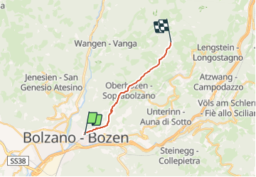
Randonnée A pied de 11,2 km à découvrir à Trentin-Haut-Adige, Haut-Adige, Eppan an der Weinstraße - Appiano sulla strada del vino. Cette randonnée est proposée par SityTrail - itinéraires balisés pédestres.
Description
Randonnée créée par AVS.
Symbole: 6 on white red flag
Localisation
Pays :
Italie
Région :
Trentin-Haut-Adige
Département/Province :
Haut-Adige
Commune :
Eppan an der Weinstraße - Appiano sulla strada del vino
Localité :
Unknown
Départ:(Dec)
Départ:(UTM)
681392 ; 5152307 (32T) N.
Commentaires
Randonnées à proximité
![Randonnée A pied Ritten - Renon - IT-26 - Photo](https://media.geolcdn.com/t/375/260/9bd03478-120d-46a7-a6d6-de72f6ce1ca7.jpeg&format=jpg&maxdim=2)
![A pied A pied](https://static1.geolcdn.com/sitytour/trail-icons/100.png)
IT-26
A pied
Facile
Ritten - Renon,
Trentin-Haut-Adige,
Haut-Adige,
Italie
![](/images/other/stat-length.png)
3,2 km | 4,7 km-effort
1h 3min
![](https://static1.geolcdn.com/siteimages/upload/files/16400158638029165_repeat_loop_refresh_sync_direction_icon.png)
Non
![Randonnée A pied Eppan an der Weinstraße - Appiano sulla strada del vino - IT-4 - Photo](https://media.geolcdn.com/t/375/260/18e6f2f6-3c27-4834-a3a2-f3468ddb090e.jpeg&format=jpg&maxdim=2)
![A pied A pied](https://static1.geolcdn.com/sitytour/trail-icons/100.png)
IT-4
A pied
Facile
Eppan an der Weinstraße - Appiano sulla strada del vino,
Trentin-Haut-Adige,
Haut-Adige,
Italie
![](/images/other/stat-length.png)
4,4 km | 12,8 km-effort
2h 54min
![](https://static1.geolcdn.com/siteimages/upload/files/16400158638029165_repeat_loop_refresh_sync_direction_icon.png)
Non
![Randonnée A pied Jenesien - San Genesio Atesino - IT-30 - Photo](https://media.geolcdn.com/t/375/260/c09e645d-a45e-4fbb-afe8-f2e4f66c98ae.jpeg&format=jpg&maxdim=2)
![A pied A pied](https://static1.geolcdn.com/sitytour/trail-icons/100.png)
IT-30
A pied
Facile
Jenesien - San Genesio Atesino,
Trentin-Haut-Adige,
Haut-Adige,
Italie
![](/images/other/stat-length.png)
5,4 km | 9,7 km-effort
2h 12min
![](https://static1.geolcdn.com/siteimages/upload/files/16400158638029165_repeat_loop_refresh_sync_direction_icon.png)
Non
![Randonnée A pied Bolzano - Bozen - IT-1 - Photo](https://media.geolcdn.com/t/375/260/08db730b-3a8b-4caa-a5cb-18a35a3e47c4.jpeg&format=jpg&maxdim=2)
![A pied A pied](https://static1.geolcdn.com/sitytour/trail-icons/100.png)
IT-1
A pied
Facile
Bolzano - Bozen,
Trentin-Haut-Adige,
Haut-Adige,
Italie
![](/images/other/stat-length.png)
7,7 km | 11,4 km-effort
2h 35min
![](https://static1.geolcdn.com/siteimages/upload/files/16400158638029165_repeat_loop_refresh_sync_direction_icon.png)
Non
![Randonnée A pied Laives - Leifers - 1 - Photo](https://media.geolcdn.com/t/375/260/c09763d5-9d76-4114-9e09-b9affe77f11e.jpeg&format=jpg&maxdim=2)
![A pied A pied](https://static1.geolcdn.com/sitytour/trail-icons/100.png)
1
A pied
Facile
Laives - Leifers,
Trentin-Haut-Adige,
Haut-Adige,
Italie
![](/images/other/stat-length.png)
6,2 km | 9,5 km-effort
2h 9min
![](https://static1.geolcdn.com/siteimages/upload/files/16400158638029165_repeat_loop_refresh_sync_direction_icon.png)
Non
![Randonnée sport Bolzano - Bozen - 2020-06-29_20h55m18_MM4 Vilabassa - Photo](https://media.geolcdn.com/t/375/260/ext.jpg?maxdim=2&url=https%3A%2F%2Fsecurestorage.geolives.com%2Fsitytour%2Ftrail-bg%2Fdefault.jpg)
2020-06-29_20h55m18_MM4 Vilabassa
sport
Très facile
Bolzano - Bozen,
Trentin-Haut-Adige,
Haut-Adige,
Italie
![](/images/other/stat-length.png)
140 km | 0 m-effort
Inconnu
![](https://static1.geolcdn.com/siteimages/upload/files/16400158638029165_repeat_loop_refresh_sync_direction_icon.png)
Non
![Randonnée Vélo Bolzano - Bozen - i2 bolzano rovereto - Photo](https://media.geolcdn.com/t/375/260/ext.jpg?maxdim=2&url=https%3A%2F%2Fstatic1.geolcdn.com%2Fsiteimages%2Fupload%2Ffiles%2F1524743154velo.jpg)
![Vélo Vélo](https://static1.geolcdn.com/sitytour/trail-icons/200.png)
i2 bolzano rovereto
Vélo
Moyen
Bolzano - Bozen,
Trentin-Haut-Adige,
Haut-Adige,
Italie
![](/images/other/stat-length.png)
93 km | 102 km-effort
Inconnu
![](https://static1.geolcdn.com/siteimages/upload/files/16400158638029165_repeat_loop_refresh_sync_direction_icon.png)
Non